Recently,
Assistant Professor Yilin Chen
's research group
from the
School of Urban Planning and Design, Peking University
, published a
study
titled
“Vertical Profile Corrections Explain Satellite–Inventory Ammonia Discrepancies and Reveal Concentrated Agricultural Sources in China.”
in the
leading environmental science journal
Environmental Science & Technology
.
The research used CMAQ modeled profiles to correct IASI-NH3 satellite column concentration observations, combined with a hybrid IMB+4DVar inversion framework to optimize ammonia emission estimates, significantly narrowing the gap between "top-down" and "bottom-up" inventories, and revealing the highly concentrated nature of China's agricultural ammonia emissions, providing a scientific basis for targeted emission control.
Research Background
Ammonia emissions are important precursors to atmospheric fine particulate matter pollution and nitrogen deposition, directly affecting air quality improvement and ecosystem health. For a long time, systematic discrepancies have existed between China's ammonia emission inventories and satellite-derived estimates, with satellite inversions typically showing that "bottom-up" inventories significantly underestimate emissions. This gap has hindered accurate quantification of ammonia emissions and made it difficult for nitrogen pollution control policies to effectively target key regions and emission sources. Understanding the root causes of this discrepancy is crucial for improving emission estimates and optimizing control measures.
Methodology
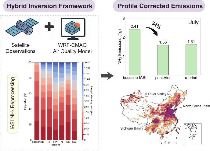
This study proposes a satellite observation constraint framework based on model profile corrections. The research team first used the regional air quality model CMAQ to simulate high spatiotemporal resolution NH₃ vertical profiles, evaluating profile reasonableness through various observations and sensitivity experiments. By replacing the default profile assumptions in IASI ANNI-v4 satellite retrievals with CMAQ-simulated vertical profiles, the team reduced column concentration biases caused by inaccurate vertical distribution characterization. Subsequently, the corrected observation column concentrations were combined with the CMAQ model using a hybrid inversion framework that integrates the Iterative Mass Balance (IMB) method for rapid correction with the four-dimensional variational (4D-Var) method for high-resolution optimization, yielding monthly posterior emission inventories at 36-kilometer grid resolution, validated through ground observations and statistical metrics.
Key Findings
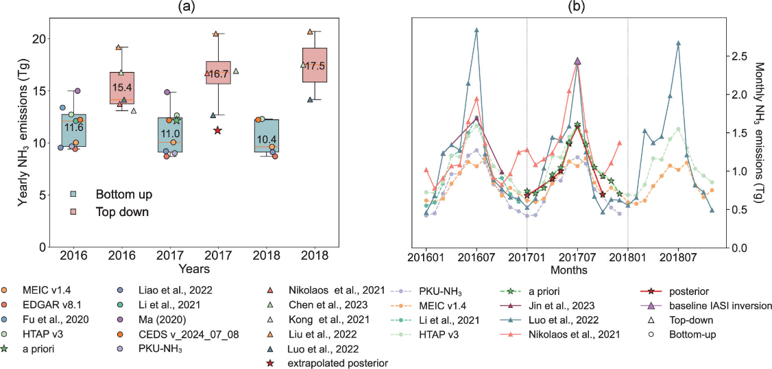
The study first compared multiple "bottom-up" ammonia emission inventories with "top-down" inversion inventories for 2016-2018. Results showed that whether examining annual totals or seasonal variations, "bottom-up" inventory estimates were significantly lower than "top-down" satellite inversions, averaging 27% lower, with the summer gap being most pronounced. This indicates that even with continuous inventory improvements, systematic differences persist between satellite and inventory estimates, necessitating identification of bias sources.

Satellite retrievals typically assume rapid near-surface ammonia concentration decay, but measured profiles show this assumption is unreasonable, leading to systematic overestimation of surface emissions by satellites. After replacing the default profile with CMAQ-simulated spatially and temporally resolved vertical profiles, the gap between satellite and model estimates decreased from 71% to 18%. Regionally, the Northwest and Southwest showed the most significant improvements, with bias reductions exceeding half, confirming that vertical profiles are a key factor in satellite-inventory discrepancies.

Building on profile corrections, the study employed a hybrid inversion framework to obtain monthly posterior emission inventories. Results showed that ammonia emission hotspots were primarily concentrated in the North China Plain, Sichuan Basin, and Xinjiang's Ili River Valley, exhibiting stronger spatial concentration. The highest-emitting 10% of grid cells contributed 54-56% of total national emissions. Compared to the a priori inventory, the posterior inventory better reflects trends in agricultural scale intensification and concentrated livestock operations.
CMAQ simulations using the profile-corrected posterior inventory showed marked improvements when compared with both IASI satellite observations and AMoN-China ground monitoring data. Spatial consistency with satellite observations during the high-emission summer period improved significantly, with normalized root mean square error decreasing by over 40% and spatial correlation coefficients increasing from 0.74 to 0.98. At 53 national ground monitoring sites, posterior simulation monthly errors decreased by 1-27%, with simulation-observation differences at typical North China Plain agricultural sites reduced by over 60%. Validation results demonstrate that the corrected emission inventory simultaneously improves model performance against both satellite and ground observations, more accurately reflecting actual emission levels.
Significance
This study clarifies that the satellite-inventory gap primarily stems from unreasonable vertical profile assumptions, and on this basis reveals the highly concentrated nature of China's ammonia emissions. These findings provide a scientific basis for implementing targeted emission reductions in hotspot regions, enhancing the effectiveness of nitrogen pollution control and nitrogen management.
Yilin Chen, Assistant Professor at Peking University's School of Urban Planning and Design, is the corresponding author of the paper, with Qiming Liu, a master's student at Southern University of Science and Technology, as the first author. The research was supported by the National Natural Science Foundation of China and the Ministry of Science and Technology of China.
Read the full paper:
https://pubs.acs.org/doi/full/10.1021/acs.est.5c08278
